Canada's Climate Zones

Rain Shadow: An area having relatively little precipitation due to the effect of a barrier, such as a mountain range, that causes the prevailing winds to lose their moisture before reaching it.
Relief Precipitation: Precipitation which results from the lifting of moist air over an orographic barrier such as a mountain range.
Polar Front Jet Stream: A high-speed, meandering wind current, generally moving from a westerly direction at speeds often exceeding 400 kilometers (250 miles) per hour at
altitudes of 10 to 15 kilometers (6 to 9miles).
Convectional Precipitation: Convective rain, or showery precipitation, occurs from convective clouds. It falls as showers with rapidly changing intensity. Convective precipitation
falls over a certain area for a relatively short time, as convective clouds have limited horizontal extent.
arctic
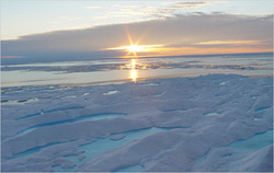
- Has a very harsh climate; the summer is very short and cool plus in the most northerly locations winter lasts as long as ten months.
-Precipitation is low because the Arctic Ocean and other bodies of water are frozen for most of the year, and there is very little
evaporation.
This region includes most of Yukon, the Northwest Territories and Nunavut.
-Precipitation is low because the Arctic Ocean and other bodies of water are frozen for most of the year, and there is very little
evaporation.
This region includes most of Yukon, the Northwest Territories and Nunavut.
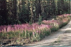
taiga
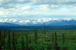
-Long, severe winters (up to six months with mean temperatures below freezing) and short summers (50 to 100 frost-free days), as is a wide range of temperatures between the lows of winter and highs of summer.
-Precipitation occurs mainly in the summer from convectional precipitation.
-Precipitation occurs mainly in the summer from convectional precipitation.
cordilleran
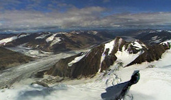
-The climate found in this area varies greatly because of the mountains. Coastal temperatures tend to be warmer than those inland, and northern climates are cooler than southern climates. Winters can last up to 8 months in
the northern part of the region.
-Locations only a few kilometres apart may have very different temperatures and
precipitation patterns.
- West facing windward slopes receive a great deal of relief precipitation while leeward slopes and interior valleys are dry because of rain shadow conditions.
-This region includes British Columbia and parts of Yukon.
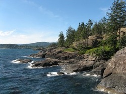
pacific maritime region
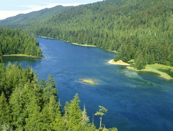
-The Pacific Maritime region lies along British Columbia's coast and its border with Alaska.
- Being so close to the Pacific Ocean, the climate is extremely altered. Summers are cooler, winters more mild.
- Relief precipitation along the coast is very high, especially in winter when the polar-front jet stream moves southward allowing moist Pacific winds to reach this area.
- Being so close to the Pacific Ocean, the climate is extremely altered. Summers are cooler, winters more mild.
- Relief precipitation along the coast is very high, especially in winter when the polar-front jet stream moves southward allowing moist Pacific winds to reach this area.
atlantic maritime
-The winters are neither as cold, nor the summers as hot as continental locations, because the Atlantic Ocean moderates the
temperatures.
-This includes New Brunswick, Nova Scotia, Prince Edward Island and southeastern Quebec.
-The Atlantic Ocean and its currents have created a cool and humid maritime climate.
temperatures.
-This includes New Brunswick, Nova Scotia, Prince Edward Island and southeastern Quebec.
-The Atlantic Ocean and its currents have created a cool and humid maritime climate.
boreal

-This region forms a continuous belt from Newfoundland and Labrador west to the Rocky Mountains and north to Alaska.
-This has a continental climate, where winters are cold and summers are warm.
-In the summer, convectional precipitation also occurs when the land heats up.
-This has a continental climate, where winters are cold and summers are warm.
-In the summer, convectional precipitation also occurs when the land heats up.
prairie
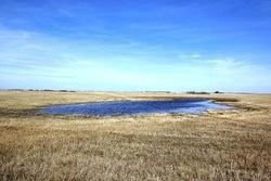
-It is a continental climate and the Prairie Provinces comprise the provinces of Alberta, Saskatchewan, and Manitoba, as they are much covered by prairie.
-Winters are very cold and summers are very hot.
-It is quite dry in this region because it is in the rain shadow of the western Cordillera.
-Winters are very cold and summers are very hot.
-It is quite dry in this region because it is in the rain shadow of the western Cordillera.
southeastern
-This area has both continental and maritime characteristics although most of the region has a continental climate with a wide range of temperature.
-The prevailing winds bring storms from the west and storms from the south move up from the Gulf of Mexico. The slight summer maximum is due to convectional precipitation.
This region includes Ontario and Quebec also parts of Nova Scotia and New Brunswick.
-The prevailing winds bring storms from the west and storms from the south move up from the Gulf of Mexico. The slight summer maximum is due to convectional precipitation.
This region includes Ontario and Quebec also parts of Nova Scotia and New Brunswick.
|
|
